- The United States does not have a history
of success in regional coordination, but
one approach that has worked focuses
on connecting hard data on the direction
the region is headed with residents’
aspirations for their communities.
- Envision Utah has cultivated broad
public support by showing residents the
challenges presented by significant population
growth in a fixed area and then
helping them develop sustainable growth
management strategies.
- Decades of large-lot home construction
have led to debilitating congestion in the
Sacramento region; through a consensus-building process, the Sacramento
Area Council of Governments has shown
people how addressing this problem will
also provide appropriate types of housing
for the anticipated future population.

Increase in bike lanes per square mile built has more workers commuting by bicycle in U.S. cities. PolicyLink
When it comes to regional coordination
around growth issues, the
United States has a less developed tradition
than many other countries, in part
because regional planning efforts often
evoke strong reactions from residents
concerned about losing local control.
As a result, relatively few regional
organizations in the United States have
been able to build consensus around
metropolitan growth management. Two
organizations that have been leaders in
building this consensus, Envision Utah
(EU) and the Sacramento Area Council
of Governments (SACOG), have found
success by tapping into people’s shared
values and aspirations while using convincing,
unbiased data to demonstrate
the need to work regionally.
“In order for communities to thrive,
[people] need to understand that the
region has to be healthy [in order to
compete] in a global market,” says Alan
Matheson, CEO of Envision Utah. In
recent years, he says, it’s become clear
that “we’re going to rise or fall together.”1
The following case studies illustrate
how the Salt Lake City and Sacramento
regions — both of which are part of the
inaugural cohort of HUD Sustainable
Communities Regional Planning Grant
recipients (see sidebar) — have
crafted successful regional planning
platforms through consensus-building
and data-focused planning scenarios.
Utah’s unique topography and rapid
growth have made regional planning
critical. Because much of the state’s
land area is desert, about 80 percent
of Utah residents live in a narrow,
120-mile strip known as the Greater
Wasatch Area. The Governor’s Office
of Planning and Budget estimates that
the region’s population will triple to 5
million by 2050.2 One consequence of
this growth is that by 2040, daily vehicle
miles traveled (VMT) in the region
are expected to double (relative to
2006 levels); assuming current trends
continue, the state’s emissions are
forecast to grow more than 70 percent
by 2030.3 Due in large part to vehicular
emissions, the levels of fine particulate
matter and ozone currently exceed the
Environmental Protection Agency’s
(EPA’s) air-quality standards in several
counties in the region.
Over the past decade, EU, the pioneering
Smart Growth coalition founded
in 1997, has emerged as a key driver of
regional planning. This public-private
partnership includes policymakers,
business leaders, developers, and
leaders of the Church of Jesus Christ
of Latter-day Saints. EU has become an
influential leader in the state because
of its broad buy-in and significant public
engagement — for example, 20,000
people participated in developing its
Quality Growth Strategy.4 EU has led cities throughout the region in land-use planning and campaigned successfully for UTA TRAX, Salt Lake County’s first light rail, which opened in 1999 and will launch two new lines by 2015.5
Good data and analysis — rigorous, transparent, and easy to understand — form the foundation of EU’s consensus-building strategy. Before getting people together to talk about planning, whether for the region or for one of many demonstration projects, EU does significant background work: baseline analyses and predictive modeling of land use, infrastructure, economic health, and other factors. Armed with a data-driven forecast of how the region will look in 40 or 50 years if current trends continue, EU can query people’s level of satisfaction with the region’s
future. Participants’ typical response has been dissatisfaction, which creates the space to have productive conversations that transcend traditional
ideological divisions and focus on
specific problems and tradeoffs.

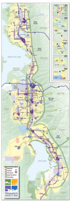
The Wasatch Choice for 2040 Vision Map displays the land uses called for in the plan, but also the different regional growth features: growth centers (blue and purple areas), mixed-use corridors (blue and purple lines), and regional greenways and connections to population centers (dark and light green arrows, respectively). Envision Utah
EU’s most recent project, a transportation planning initiative called Wasatch Choice for 2040, builds on this success by emphasizing transit-oriented development (TOD) in the Wasatch region’s fastest-growing counties. As with all of EU’s initiatives, Wasatch Choice for 2040 was conceived with numerous partner organizations and participation from local residents. The initiative’s growth scenario ties new residential development to existing transportation and other infrastructure, focusing on growth centers that act like “sponges” for new development. Matheson explains that this planning strategy shows other communities throughout the
region how TOD is “sensitive to neighborhood context, creates regional benefits, and succeeds in the marketplace.”6
The projections for the Wasatch Choice plan are encouraging. By 2040, 11 percent of housing and 20 percent of jobs will be within walking distance of high-capacity transit, a significant increase from the current levels of 2 percent and 12 percent, respectively. This scenario will also conserve 23 square miles of open space, reduce traffic congestion by 18 percent, and increase transit use by 12 percent.7 Over the next 20 years, the expected savings in infrastructure, housing, and transportation costs will total $4.5 billion.8
Although Utah residents are adamant about maintaining local control, they also want their region to be successful. Matheson says that EU has conducted value studies showing that people’s shared values outweigh their disagreements; a shared knowledge base, created through strong, unbiased data, enables people to reach a surprising level of consensus. This agreement has resulted in strong grassroots support for the plan — which is imperative, because participation is entirely voluntary — and elected officials from the communities in the planning area have taken notice. Most of the area’s 97 communities have already enacted changes to zoning and other regulations in response to the regional vision. The public’s support is manifested in different venues. In town meetings, citizens now commonly ask how policies under discussion will align with Wasatch Choice. People have also expressed their support in the voting booth. A referendum to raise tax money for transit, held in 1997 before EU was founded, was soundly defeated; in 2006, voters passed the same referendum by
a margin of 2 to 1.

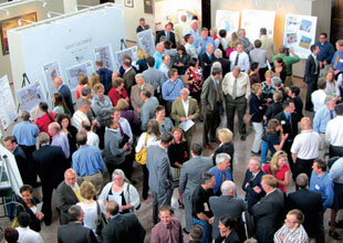
The kickoff event for Wasatch Choice for 2040, June 2011. Envision Utah
Salt Lake City has been successful in its efforts to make the Wasatch regional vision for sustainable development a reality. The city is in the midst of a code revision project and has established an expedited review for projects that meet LEED Silver criteria and/or have an ENERGY STAR rating of 85. In 2008 Mayor Ralph Becker signed a resolution to reduce Salt Lake City’s carbon footprint by 20 percent below 2005 levels by 2020 and by 80 percent below 2005 levels by 2050, and the city has secured federal funding to help meet this goal.9 A U.S. Department of Energy grant has paid for substantial upgrades to the city’s cycling infrastructure and has allowed the city to install LED streetlights, reducing its overall annual energy consumption by 4 percent.10 Using funding from a 2009 EPA grant, the city is engaging in community-based social marketing to promote sustainable transportation options. As of August 2010, these activities had already reduced VMT by 1.3 million miles, and the grant is expected to reduce greenhouse gas emissions by 63,000 metric tons by 2012.11
The city of Sacramento, California is home to more than 400,000 people in a region of 1.3 million. After rapid growth in the 1990s and early 2000s, the chief components of its economy — housing construction and government — have suffered due to the recession and California’s ongoing fiscal crisis. Nevertheless, the region is expected to recover in the coming decades, adding 1.2 million new residents and 535,000 new jobs by 2035.12

Pedestrian-friendly neighborhoods with accessible farmers markets, shops, and parks help reduce a community’s carbon footprint.
In recent years, local leaders have realized that poor land-use planning has taken its toll. In 2002, for instance, SACOG projected that the region’s
already-heavy congestion would
increase by more than 50 percent by 2025.13 This growing congestion problem is especially troublesome because the region does not meet federal air quality standards for ozone. Many local leaders are also concerned about suburban sprawl, which threatens to consume open space and farmland in a region that is a major agricultural center.
SACOG developed their Sacramento Region Blueprint using computer modeling and input from more than 5,000 residents. In the process, SACOG employed key elements of EU’s model; they used hard data to connect people’s core values to the details of community and regional planning. Focusing on data allowed SACOG’s staff to circumvent planning terms that people might perceive as threatening. For instance, SACOG’s research found that the concept of “density” had a negative connotation for many people despite being a crucial element of sustainability planning. SACOG’s market and demographic research showed that the region’s population would become significantly older over the next several decades and that this older segment would demand housing other than the single-family, large-lot homes currently being built. SACOG decided to “[focus] like a laser on these facts” at the beginning of planning sessions, and “we challenged people to confront the future,” says Mike McKeever, CEO of SACOG.14 The organization then asked people to think about the kinds of housing that each demographic group would need in the coming years. In this way, SACOG cast the discussion in terms of the people’s choices rather than those of the planners.
McKeever says that it is encouraging to see how consensus can arise “when you put ordinary people together, give them helpful information, and get out of the way.”15 McKeever credits the combination of an earnest citizen engagement process, which avoided steering participants toward a predetermined conclusion, and the fact that people had the information they needed to determine the best solutions themselves. The integrity of the process has changed people’s minds. Before the planning process, 70 percent of people thought that growth would degrade their quality of life; afterward, 70 percent thought that growth would improve their quality of life, provided their leaders followed the principles of the Blueprint.
In 2004 SACOG adopted its Preferred Blueprint Scenario. The Blueprint illustrates how the area could grow healthier through 2050 with land-use planning to reduce VMT and improve air quality.
By emphasizing TOD, for instance, the Blueprint will locate 41 percent of new jobs and 38 percent of new housing
within walking distance of bus or train service, compared with 5 percent of new jobs and 2 percent of new housing at
present.16 The Blueprint has also informed SACOG’s development of the Metropolitan Transportation Plan for 2035, which will add light rail and highway lanes for carpools and commuter buses as well
as increase bus frequency. As a result,
per-household VMT is forecast to
decrease 10 percent by 2035.17
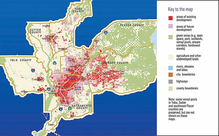
BLUEPRINT: Projected Development in 2050

SACOG’s Blueprint Scenario projects the effects of using smart land-use planning to reduce vehicle miles traveled and to improve air quality. SACOG
In concordance with the regional Blueprint plan, the city of Sacramento has enacted numerous transportation-oriented programs of its own to reduce VMT and vehicular emissions. In 2009 the city completed a general plan update that McKeever cites as an excellent model of Blueprint implementation. A key initiative is a change in the traffic level-of-service policy, which has allowed the city to suspend road widening, thus saving money and reducing impediments to walking and biking. The city has also initiated traffic-calming measures and adopted a “complete streets” initiative. These programs are critical, given that on-road transportation accounted for 42.7 percent of the city’s total greenhouse gas emissions.18
Taken together, these initiatives seem to be having a positive effect:
-
Between 2008 and 2009, all types of collisions — involving pedestrians,
bicycles, parked cars, and other
vehicles — declined;
- In 2010 the city had its best air quality in more than 5 years, failing to meet federal and state air-quality standards for 8-hour maximum ozone concentrations on only 4 days (down from 21 the previous year); and
- Weekday VMT per capita decreased from 14.5 miles in 2005 to 14 miles
in 2008.
The city’s 2030 General Plan projects a 13.2 percent reduction in VMT per capita and an 11.1 percent reduction in car trips per capita.19 Because of these and other initiatives, the city and the region are well prepared to comply with AB-32 (from 2006) and SB-375 (from 2008), California legislation designed to decrease greenhouse gas emissions and curb sprawl, respectively.
Both Envision Utah and SACOG want to use their Sustainable Communities Regional Planning grants to make their planning processes more comprehensive. These organizations see these grants as an opportunity to strengthen the connections between the physical plan and socioeconomic factors. “It’s pushing us to broaden the engagement tent even more and to really make sure we have
a [comprehensive] treatment of the social equity issues in the region,” says McKeever. SACOG will be looking at the economic and ethnic distribution across the region and evaluating and managing the effects of rising property values.
SACOG would also like to better incorporate information about nontransportation infrastructure — including water and sewer, surface-water management, and energy — into their planning process. Matheson hopes to enhance people’s connections to the process and to each other, whether that means strengthening the bonds between various groups and institutions or expanding EU’s engagement model to new sectors and areas of the state. That also means continuing to spread the word, particularly to the private sector, that regional planning is economically smart.
As we learn more from Salt Lake City, Sacramento, and other U.S. regional planning efforts, it will be important to carefully monitor their outcomes in order to help develop and refine best practices for measuring and enacting sustainable development. Until then, one lesson from the successes of EU and SACOG seems clear; regardless of their background or political orientation, people care about the success of their region. An inclusive planning process
focused on empirical data about the
future of the region will help build consensus on a way forward.
:
The Costs of Sprawl
Sustainable Communities Research Grant Program
The Federal Role in Regional Planning
- Interview with Alan Matheson, June 2011.
- Envision Utah. n.d. “The History of Envision Utah,” 28. Accessed 31 May 2011.
- Governors Office of Planning and Budget, Envision Utah, and Utah Quality Growth Commission. John F. Bennett, ed. 2008. “Utah Baseline Report: Current Conditions, Trends, and Projections,” 12.
- Interview with Peter Calthorpe, June 2011.
- “About Trax.” Utah Transit Authority website. Accessed 1 June 2011.
- Interview with Matheson.
- Envision Utah. n.d. “Wasatch Choices 2040: A Four County Land-Use and Transportation Vision (website content has changed and this document is no longer available),” 22–3. Accessed 2 June 2011.
- Wasatch Front Regional Council. n.d. “Wasatch Choice for 2040 Brochure,” 3. Accessed 31 May 2011.
- “City Carbon Inventory and Reduction Goals.” Salt Lake City website. Accessed 3 June 2011.
- Correspondence with Mike Barry, July 2011.
- “Sustainable Transportation for a Sustainable Future.” U.S. Environmental Protection Agency website. Accessed 2 June 2011.
- Sacramento Area Council of Governments. 2010. “Special Report: Blueprint’s Impact on the Region and Residents’ Quality of Life,” 13.
- Ibid., 2.
- Interview with Mike McKeever, July 2011.
- Ibid.
- Sacramento Area Council of Governments. 2010, 4.
- Sacramento Area Council of Governments. 2008. “Final Environmental Impact Report for the Metropolitan Transportation Plan for 2035,” 2-17; Sacramento Area Council of Governments. 2007. “Draft Environmental Impact Report for the Metropolitan Transportation Plan for 2035,” Table 18-7.
- “City of Sacramento Climate Action Plan.” 2010. City of Sacramento General Plan Update website. Accessed 30 May 2011.
- City of Sacramento. 2009. “2010 Annual Report: Sacramento 2030 General Plan,” 16–35.
Evidence Matters Home Previous Article
|


